Introducing the very real Kafka Metro in Brussels
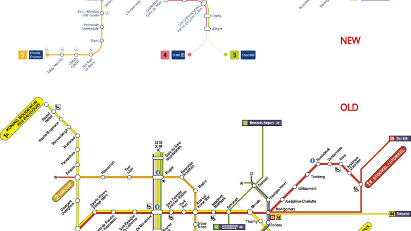
The Onion has done an ace spoof on modern airports – Prague’s Franz Kafka Airport. For anyone that has had the misfortune to pass through Terminal 3 at London Heathrow some of this is just a little too close to the truth… and it’s also very close to the truth when it comes to the re-organisation of the Brussels Metro, due to start on 3rd April. Here are the new and old metro maps (click for a larger version):

Essentially the change is that the piece of line between Clemenceau and Gare de l’Ouest, via Delacroix, has now been completed. Despite some efforts by STIB, the operator, to explain things, I reckon this is going to cue chaos.
- Essentially there were 2 lines before: 1A / 1B that ran east-west, with branches at each end, and line 2 that run in a part circle. Now we have lines 1 and 5 that run through the city, line 2 that runs in a circle, and line 6 that runs from the suburbs into the circle. Line 1 runs parallel to line 5, and line 2 parallel to line 6.
- So what about lines 3 and 4? Those are actually trams that run underground for a bit. These lines are sometimes labelled as trams, and sometimes as metro and even sometimes as prémetro, and they don’t appear at all on the line maps most prominently displayed in Metro stations.
- Line 2 (and 6, sort of) runs in a circle. Only it’s not a complete circle – trains start / stop at Simonis (Leopold II) and Simonis (Elisabeth). So if you’re at one of the other stations on the circle you have to know which version of Simonis to head for and – unlike the Circle Line in London or the Ringbahn in Berlin, where trains are clearly going clockwise or anti-clockwise – you have to know your destination station on a circular line.
- Line 2 (orange) and Line 5 (yellow) are rather similar shades – surely not easy for the short sighted or colour blind?
- Station names and destinations are only announced in the handful of new Metro trains. In the rest of the old trains there’s one grimy sign inside each carriage that states the final destination. If the maps are complex then at least some help in the trains would be handy.
Anyway, I reckon I have more or less worked it out, and I’m a public transport geek. How tourists or Commission Officials are going to understand it I have no idea…
Next week Jon has a moan about the BBC weather map; “stick on clouds were much easier”.
Oh yeeeeees, everyone got so confused….
Especially as they decided to get a headstart by replacing all the maps in all the stations about 3 weeks ahead of schedule.
So anyone not knowing where they’re going (tourists, out-of-towners…) relied on the maps, having no idea that the trains hadn’t actually changed yet, and got utterly lost.
And everyone who DID know where they’re going ALSO got lost, because they thought “Oh yay, the trains have changed already!”
STIB must have realised the error of their ways, because about 3 days before the actual change, the old maps were back alongside the new ones, all duly sticked up with little notes saying “until / from April 4th”
Instead of creating two separate services – line 2 and line 6 – they should have just one line, with some services stopping/starting short. What they’ve done is take the new service pattern, which doesn’t need to be anything other than an internal affair, and over-complicate the material they’re putting out to the public.
In fact, it’s much ado about not very much (partly with an eye on the regional election in June). A few hundred metres of new track is being opened for service (coupled with the recent introduction of a new fleet of trains and a new depot for them) creating the new direct connection between Gare du Midi and Heysel. As to the rest, they’re just rearranging services, first to increase resilience and frequency on the core, most heavily used parts, and second to remove the time-consuming and operationally inconvenient reversal of line 1A services at Beekant. Of regular users, I’d guess a significant majority will see next to no difference. The main inconvenience comes to those doing long E-W journeys who will now have to change trains (but not platforms) at Beekant (or Arts-Loi and Simonis).
As to causing chaos? Well, they’ve effectively been running the new service pattern since last Monday (but not to a published timetable) and there have evidently been some problems judging by the long waits and bunged trains I’ve been suffering. We’ll see how it beds down after the Easter break.
Jon,
When I first came to Brussels, some 13 years ago, I found the metro/premetro system quite confusing. But after some years I now know how to get from A to B, even when only being a regular visitor. My experience is that the service is very frequent and reliable, though for getting to the EU quarter when coming from Holland I prefer to take the train and get off at Schuman (Berlaymont) or Luxembourg (EP). Unfortunately the trains from Holland don’t stop at the Noord station anymore, which means that total travel time to Schuman/Luxembourg tends to be longer.
What always strikes me is the seventyish ‘design’ of the Brussels metro system. A lot of orange and these light brown tiles. Premises are often very spacious (I guess some building company was behind this) and it is often hard to find the fastest route to the right exit.
You should also have mentioned the printed Brussels public transport maps — unique in their complexity. But maybe they have been improved now.
sorry. jon’s right. the brussels metro map system is utterly dysfunctional in comparison to that of the london underground. even with the old system, you had to memorise the terminus to know where to go, instead of the line and the direction. the new system is even worse, as you still have to memorise the termini, but two of the termini have the same name! i regularly get lost on the metro if at any time i stray off my usual st-gilles-schuman trajectory.
Bee Gees on the Metro sounds to me like something out of my Room 101… They were playing Santana yesterday though, not too bad.
Bicycles point is a good one. Berlin S-Bahn is also good for this.
I love the Brussels Metro. Not only can you take bicycles on it but there is a whole station named after Eddy Merckx, the greatest cycle racer of all time and major national hero in Belgium.
I also love the music that gets played over the metro tannoy. Whoever is in charge has an eclectic and inspired record collection. I particularly remember one late night hearing the Bee Gee’s More than a Woman from the Saturday Night Fever soundtrack followed by a groovy 1970s jazz-orchestral interpretation of Bach’s Toccata and Fugue in D minor and then Amoureux Solitaire by Lio, the early 80s Brazilian-Belgian pop séductrice. London’s underground has a long way to come.
That’s precisely the point! It *was* rather simple, with 2 lines. Now with the re-organisation it becomes more complex than it needs to be.
Heathrow – never transferred through T5. But anything at LHR is always a mess, although T5 itself is a bit better than the rest.
Jon, I don’t speak a word of French nor Dutch, and yet I have found the Brussels metro system one of the easiest in Europe.
When it comes to transferring from Heathrow’s terminal 5 to any of the old terminals, however, it’s been a torture! Have you tried it?